Destinations
North Carolina outdoors
From the East's highest peak to wild barrier-island beaches, North Carolina packs mountains, waterfalls, and 300+ miles of coast into one state.
Top parks in North Carolina
See all 44 parks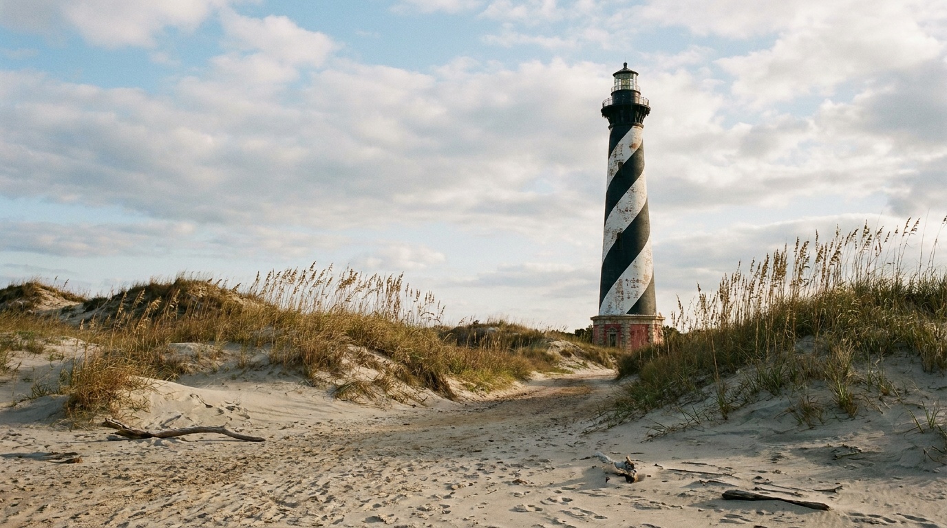
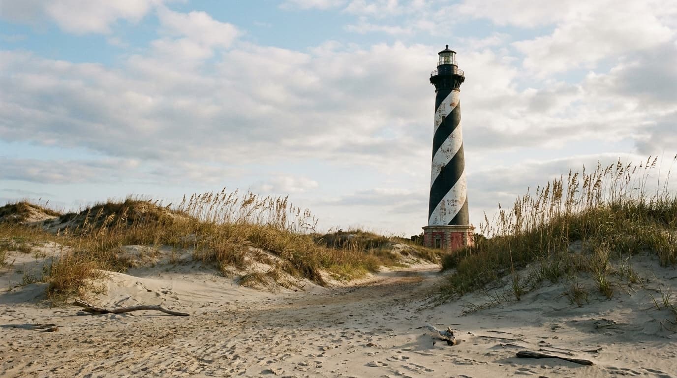
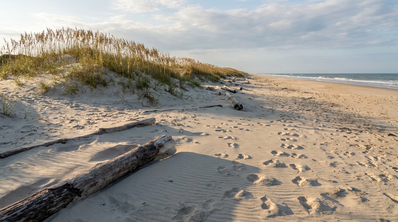
Cape Hatteras National Seashore
The Outer Banks barrier-island seashore: 70 miles of open beach, lighthouses, world-class surf-fishing, and four NPS campgrounds you reserve on Recreation.gov.
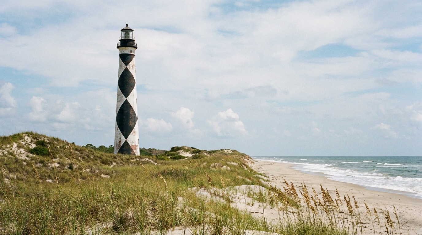
Cape Lookout National Seashore
A 56-mile chain of undeveloped barrier islands reachable only by passenger or vehicle ferry, home to the diamond-painted lighthouse and the wild horses of Shackleford Banks.
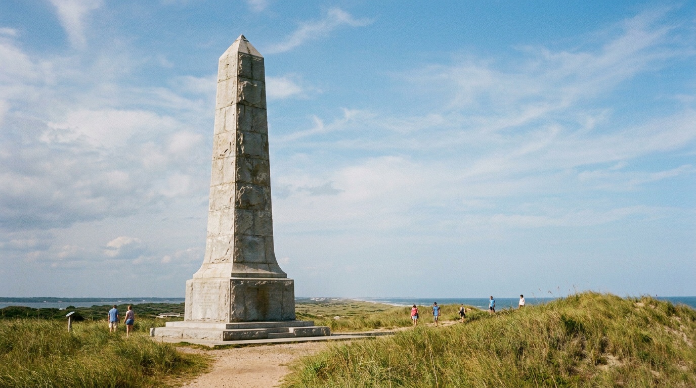
Wright Brothers National Memorial
The Outer Banks site where Orville and Wilbur Wright made the first powered flights in 1903, marked by a granite monument on Kill Devil Hill and stones tracing each takeoff.
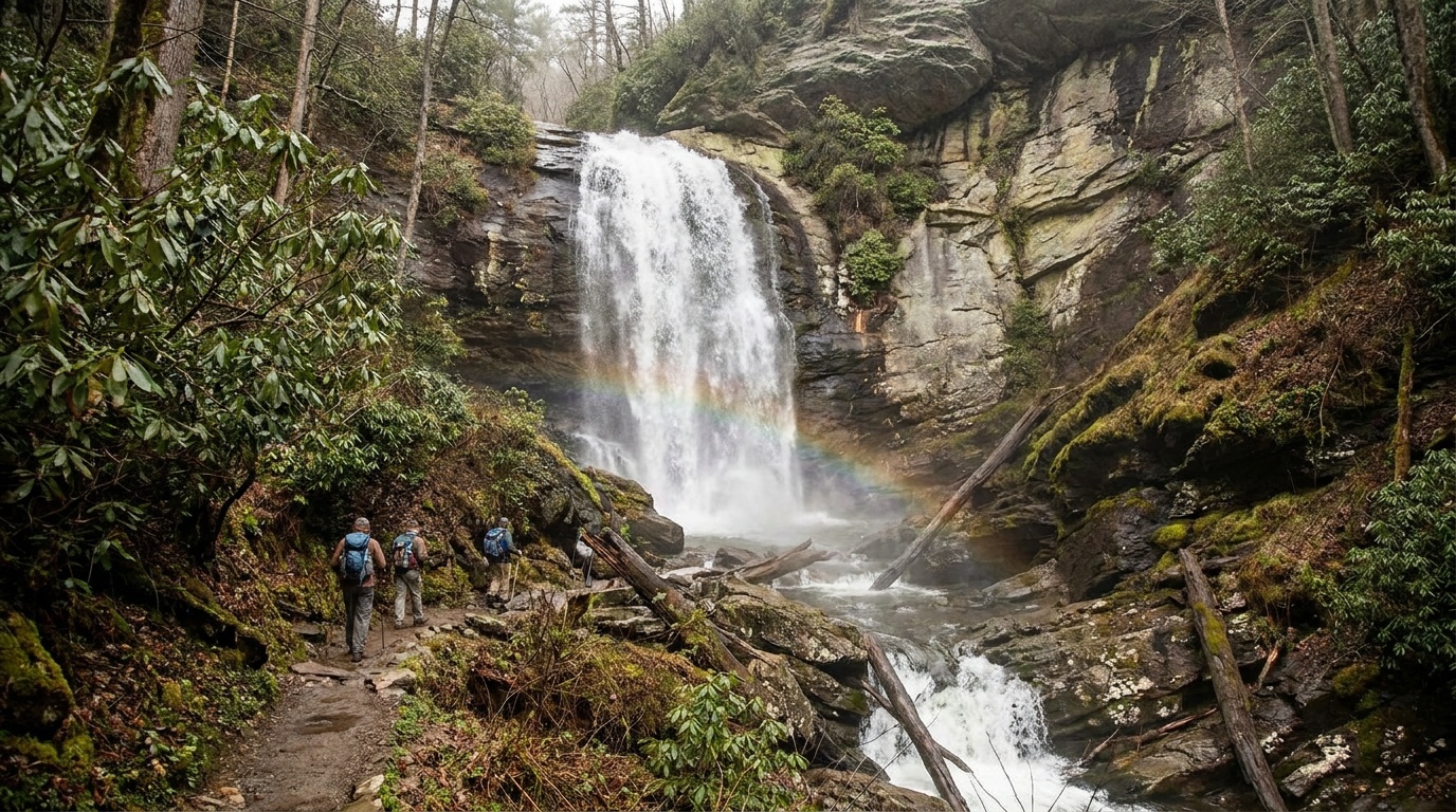
Gorges State Park
A rugged, rain-soaked gorge park in North Carolina's Blue Ridge escarpment, with steep waterfall hikes including Rainbow Falls, rare temperate rainforest plant life, and a backcountry feel close to Cashiers.
Hammocks Beach State Park
A ferry-access barrier-island park on North Carolina's southern coast, where a passenger boat carries visitors to undeveloped Bear Island for swimming, shelling, paddling, and primitive beach camping.
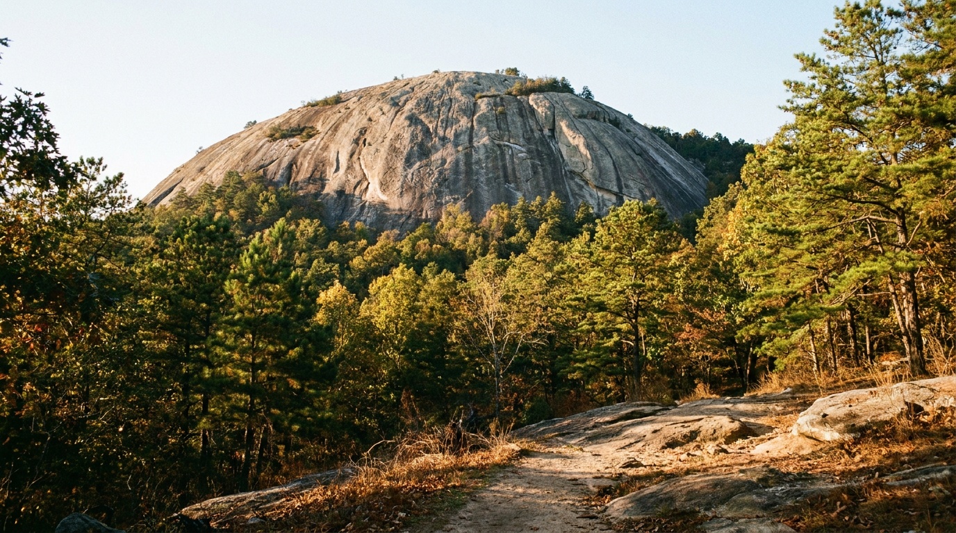
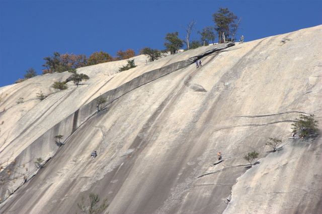
Stone Mountain State Park
A North Carolina Blue Ridge foothills park built around a 600-foot granite dome, with a strenuous summit loop, a 200-foot waterfall, world-class rock climbing, trout streams, and a large family campground.
Carolina Beach State Park
A coastal park near Wilmington known as a home of the Venus flytrap, with a marina providing access to the Cape Fear River and Intracoastal Waterway.

Carvers Creek State Park
A Cumberland County park featuring the historic Long Valley Farm and multiuse trails through longleaf pine ecosystems northwest of Fayetteville.

Chimney Rock State Park
A mountain park southeast of Asheville overlooking Hickory Nut Gorge and Lake Lure, with a 315-foot rock spire and the rugged Rumbling Bald access.
Planning a North Carolina trip
North Carolina gives you two very different outdoor worlds in one state, and the drive between them is part of the fun. In the west, the Blue Ridge and Great Smoky Mountains stack up mile-high peaks, cascading waterfalls, and more salamander species than anywhere on earth. Out east, the Outer Banks unspool into wild barrier islands where the beaches stay undeveloped for miles and wild horses still roam the dunes.
The mountains are the headline act. Mount Mitchell, at 6,684 feet, is the highest point anywhere east of the Mississippi, and the summit observation deck rewards the climb with views that run roughly 85 miles on a clear day. Nearby, Chimney Rock and Grandfather Mountain deliver dramatic rock and ridgeline, Gorges State Park protects a rugged 8,000-acre tangle of waterfalls, and Stone Mountain draws climbers to its big granite dome. Around Asheville, the half-million-acre Pisgah and the even larger Nantahala national forests open up hundreds of miles of trail, whitewater, and waterfall hikes. The Blue Ridge Parkway threads it all together with more than 100 trailheads and over 300 miles of side trails. On the coast, the Cape Hatteras and Cape Lookout national seashores trade peaks for shelling, surf fishing, lighthouses, and the tallest living sand dune on the East Coast at Jockey's Ridge.
For the mountains, late spring through October is the sweet spot, with summer highs comfortable at elevation and October peaking for fall color. For the coast, April to June and September to October give you warm water and thinner crowds while dodging the worst of summer heat and the August-to-October hurricane peak. What you pack changes with where you point the car: mountain trips call for layers, real rain protection, and trail shoes with grip for wet rock and roots, while the coast wants sun cover, water shoes, and a windbreaker for the dunes. The one constant is sturdy footwear and a way to carry water, because both ends of the state put real miles under you.
Getting around North Carolina
North Carolina has three useful air hubs depending on which half of the state you are after. Charlotte Douglas (CLT) is the big connecting airport and sits about a 2-hour, 130-mile drive from Asheville and the western mountains. Asheville Regional (AVL) is the closest option for the Blue Ridge, just a short hop from downtown Asheville and the Pisgah and Nantahala forests. Raleigh-Durham (RDU) anchors the central part of the state and is the most sensible jumping-off point for the coast.
Distances here are real, so plan around them. Asheville to Charlotte is roughly 130 miles (about 2 hours). The big one is mountains to coast: Asheville out to the Outer Banks runs about 460-470 miles and takes 7 hours or more, so most people treat the western mountains and the barrier islands as two separate trips rather than one loop. Within the mountains, the Blue Ridge Parkway is the spine that links Mount Mitchell, the Asheville-area forests, and the Smokies, though it is a slow, scenic road, not a fast highway, so budget extra time. On the coast, NC Highway 12 strings together the Outer Banks villages and the Cape Hatteras seashore, but watch the forecast: nor'easters and tropical storms can flood and close sections of it with little warning.
All 6 North Carolina park guides
State park directory
Every North Carolina state park
A source-backed inventory layer for planning breadth. Full Kit Authority guides are marked when a park has camping detail, rules, and packing notes; the rest link straight to the official page. Looking for rail trails and state trails? They have their own Trail Guide.
44 parks
3 full guides · 40 with photos
Gorges State Park
State Park
A Blue Ridge Escarpment park near the tripoint of three states with plunging waterfalls, rugged river gorges, and over 8,000 acres of temperate rainforest.
- Hiking
- Biking
- Horseback Riding
- Fishing
North Carolina State Parks
Full guideHammocks Beach State Park
State Park
An Onslow County park comprising a mainland area and three barrier islands, including Bear Island, reached by passenger ferry for oceanside camping.
- Hiking
- Paddling
- Swimming
- Fishing
North Carolina State Parks
Full guideStone Mountain State Park
State Park
A park home to a 600-foot granite dome National Natural Landmark and the historic Hutchinson Homestead, with waterfalls and trout streams northwest of Winston-Salem.
- Hiking
- Horseback Riding
- Fishing
- Picnicking
North Carolina State Parks
Full guideCarolina Beach State Park
State Park
A coastal park near Wilmington known as a home of the Venus flytrap, with a marina providing access to the Cape Fear River and Intracoastal Waterway.
- Hiking
- Biking
- Paddling
- Fishing
North Carolina State Parks
Official pageCarvers Creek State Park
State Park
A Cumberland County park featuring the historic Long Valley Farm and multiuse trails through longleaf pine ecosystems northwest of Fayetteville.
- Hiking
- Biking
- Picnicking
- Fishing
North Carolina State Parks
Official pageChimney Rock State Park
State Park
A mountain park southeast of Asheville overlooking Hickory Nut Gorge and Lake Lure, with a 315-foot rock spire and the rugged Rumbling Bald access.
- Hiking
- Fishing
- Picnicking
- Climbing
North Carolina State Parks
Official pageCliffs of the Neuse State Park
State Park
A Wayne County park sitting on 90-foot bluffs overlooking the Neuse River, with longleaf pine restoration areas and an 11-acre lake.
- Hiking
- Biking
- Paddling
- Swimming
North Carolina State Parks
Official pageCrowders Mountain State Park
State Park
A Piedmont park west of Charlotte with two mountain peaks, towering cliffs, and the Ridgeline Trail connecting into South Carolina.
- Hiking
- Paddling
- Fishing
- Picnicking
North Carolina State Parks
Official pageDismal Swamp State Park
State Park
A Camden County park providing access to the Great Dismal Swamp, the largest remaining swamp in the eastern United States, along the historic Dismal Swamp Canal.
- Hiking
- Biking
- Paddling
- Fishing
North Carolina State Parks
Official pageElk Knob State Park
State Park
A high-country park north of Boone protecting Elk Knob and the headwaters of the North Fork of the New River, with a summit overlook and backcountry campsites.
- Hiking
- Picnicking
- Backpacking
- Winter Sports
North Carolina State Parks
Official pageEno River State Park
State Park
A park spanning seven access areas along the Eno River northwest of Durham, popular with anglers, birdwatchers, and photographers and part of the Mountains-to-Sea State Trail.
- Hiking
- Paddling
- Fishing
- Picnicking
North Carolina State Parks
Official pageFalls Lake State Recreation Area
State Recreation Area
A reservoir recreation area east of Durham with seven access areas, more than 300 campsites, and a premier Triangle-area mountain bike trail system.
- Hiking
- Biking
- Paddling
- Swimming
North Carolina State Parks
Official pageFort Fisher State Recreation Area
State Recreation Area
A coastal recreation area south of Wilmington, the only park in the system allowing four-wheel-drive beach access, with a salt marsh trail and sea turtle nesting beaches.
- Hiking
- Paddling
- Swimming
- Fishing
North Carolina State Parks
Official pageFort Macon State Park
State Park
A Carteret County park centered on a restored pre-Civil War fort with guided tours, beaches, and salt marsh and dune trails.
- Hiking
- Biking
- Paddling
- Swimming
North Carolina State Parks
Official pageGoose Creek State Park
State Park
A Beaufort County park offering coastal experiences from Pamlico River wetlands to a cypress swamp boardwalk southeast of Greenville.
- Hiking
- Paddling
- Swimming
- Fishing
North Carolina State Parks
Official pageGrandfather Mountain State Park
State Park
A rugged mountain park southwest of Boone with cliffs, cables, and ladders, recognized as a United Nations International Biosphere Reserve.
- Hiking
North Carolina State Parks
Official pageHanging Rock State Park
State Park
A Stokes County park born from a Civilian Conservation Corps project, offering mountain views, waterfalls, a swim lake, and Dan River paddling north of Winston-Salem.
- Hiking
- Biking
- Horseback Riding
- Paddling
North Carolina State Parks
Official pageHaw River State Park
State Park
A park north of Greensboro centered on The Summit environmental education center, with boardwalk trails through wetlands and a floodplain swamp.
- Hiking
- Picnicking
- Fishing
North Carolina State Parks
Official pageJockey's Ridge State Park
State Park
An Outer Banks park home to the tallest living sand dune system on the Atlantic coast, popular for hang gliding, kite flying, and watersports on Roanoke Sound.
- Hiking
- Picnicking
- Paddling
- Swimming
North Carolina State Parks
Official pageJones Lake State Park
State Park
A Bladen County park on a Carolina bay lake that opened as the first state park to welcome Black Americans, southeast of Fayetteville.
- Hiking
- Paddling
- Swimming
- Fishing
North Carolina State Parks
Official pageJordan Lake State Recreation Area
State Recreation Area
A Chatham County recreation area west of Raleigh with seven access areas, more than 1,000 campsites, and one of the largest summer bald eagle populations.
- Hiking
- Paddling
- Swimming
- Fishing
North Carolina State Parks
Official pageKerr Lake State Recreation Area
State Recreation Area
A recreation area of eight access areas around a 50,000-acre reservoir on the Virginia border, with seven campgrounds and boat ramps for fishing.
- Hiking
- Paddling
- Swimming
- Fishing
North Carolina State Parks
Official pageLake James State Park
State Park
A park northeast of Asheville with two access areas on a lake suited for boating, swimming, and fishing, plus campsites and bike trails.
- Hiking
- Biking
- Paddling
- Swimming
North Carolina State Parks
Official pageLake Norman State Park
State Park
An Iredell County park on the state's largest manmade lake north of Charlotte, with the nearly 31-mile Itusi mountain biking trail system.
- Hiking
- Biking
- Paddling
- Swimming
North Carolina State Parks
Official page


Inventory source: USGS PAD-US 4.1. Photos are public-domain or Creative Commons via Wikimedia Commons, credited per image. Official reservations and rules remain state-specific, so use the state booking links before committing to dates.
Native plants of North Carolina
North Carolina's parks climb from Atlantic dunes to the highest peaks east of the Mississippi, and the mountain spring wildflower show rivals anywhere in the country. Most of these woodland natives settle happily into a shaded Piedmont yard.
Eastern red columbine
Aquilegia canadensis
Red-and-yellow nodding flowers on rocky slopes and trail cuts in April.
An easy self-sower for part shade. Grow itFoamflower
Tiarella cordifolia
Spires of white froth across rich mountain coves in spring.
A spreading groundcover for moist shade. Grow itBloodroot
Sanguinaria canadensis
Pure white flowers pushing through leaf litter in the first warm week of March.
An early ephemeral for a woodland bed. Grow itCarolina allspice
Calycanthus floridus
Maroon, fruit-scented flowers on an understory shrub of the southern Blue Ridge.
A fragrant native shrub for part shade. Grow itFlame azalea
Rhododendron calendulaceum
Orange bloom on high balds and ridgelines in June, one of the Blue Ridge's signature sights.
Cardinal flower
Lobelia cardinalis
Intense red spikes along creeks and seeps in late summer.
A hummingbird beacon for damp ground. Grow itChristmas fern
Polystichum acrostichoides
The evergreen fern holding winter slopes together in every Piedmont and mountain park.
An evergreen fern for dry shade. Grow it
Grow-at-home guides for these come from our sister site, Sprout Authority.
Frequently asked questions
What is the best time to visit North Carolina's parks?
It depends on which end of the state you mean. For the mountains, late spring through October is ideal, with comfortable temperatures at elevation and peak fall color in October. For the coast and the Outer Banks, target April through June or September into October, when the water is warm, crowds are thinner, and you mostly avoid the August-to-October peak of hurricane season.
Does North Carolina have a national park?
North Carolina does not have a standalone national park entirely within its borders, but it shares Great Smoky Mountains National Park with Tennessee, and it is the most-visited national park in the country. The state also has two national seashores on the coast, Cape Hatteras and Cape Lookout, plus the half-million-acre Pisgah and Nantahala national forests in the west. Add in standout state parks like Mount Mitchell, Chimney Rock, and Gorges, and there is no shortage of public land.
What is the best outdoor area in North Carolina for first-time visitors?
For a first trip, the area around Asheville is hard to beat. You get the Blue Ridge Parkway, easy access to Pisgah National Forest's waterfalls and trails, and day-trip range to Mount Mitchell and Chimney Rock. If you would rather have beaches and barrier islands, base yourself on the Outer Banks and explore Cape Hatteras and Jockey's Ridge instead.
How high is Mount Mitchell and can you drive to the top?
Mount Mitchell tops out at 6,684 feet, making it the highest peak anywhere in the United States east of the Mississippi River. You can reach the summit area by car via a spur road off the Blue Ridge Parkway, then walk a short paved path to the observation deck, where views can stretch around 85 miles on a clear day. Because it is so high, the summit runs noticeably cooler and windier than the valleys, so bring a layer even in summer.