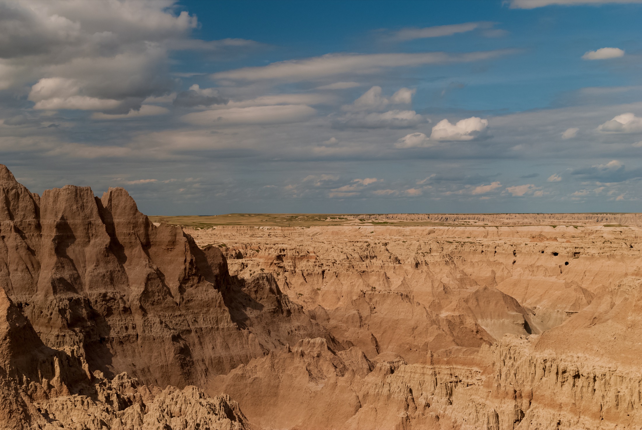
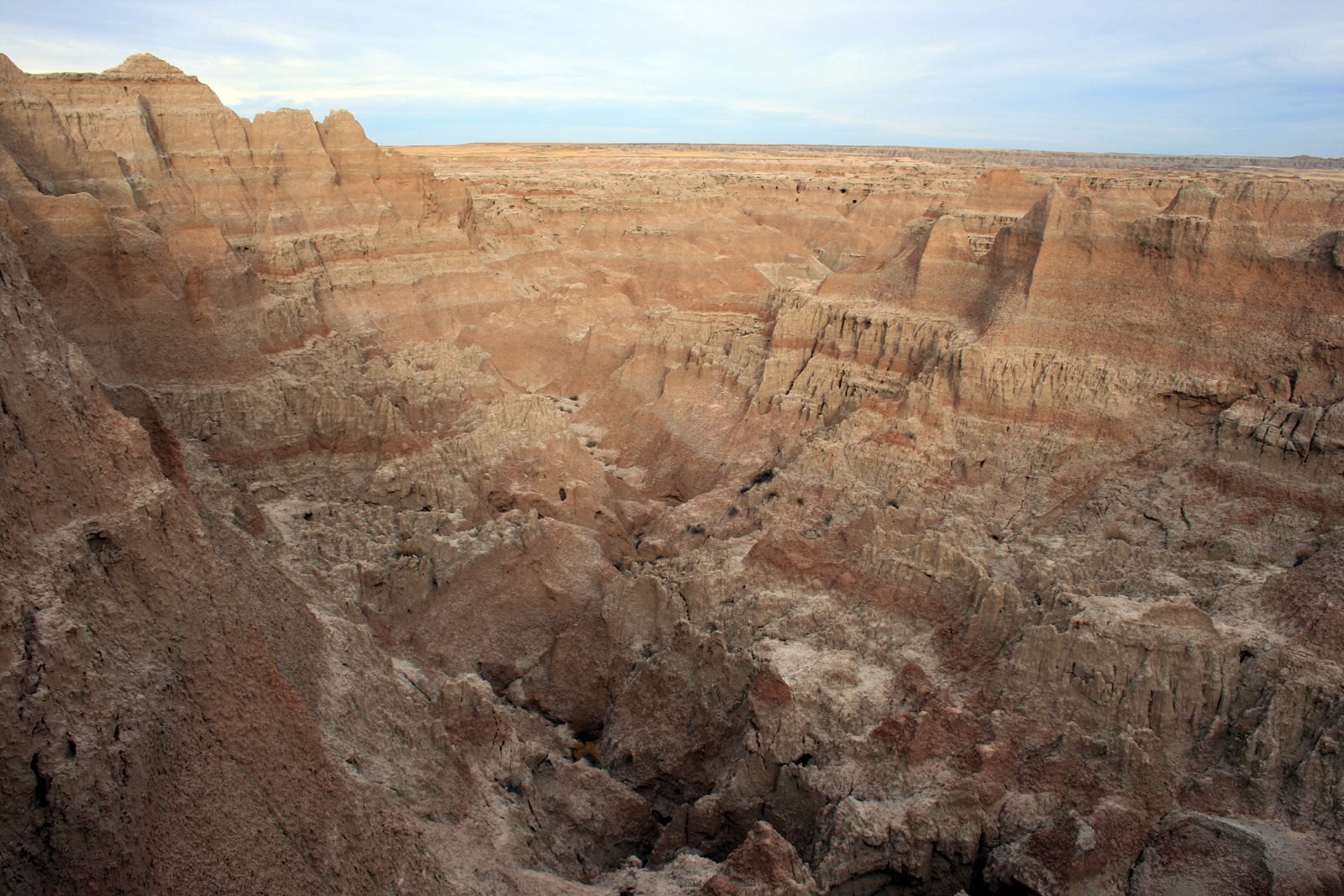
Skip to content
KITAUTHORITY
Wide panorama of the eroded buttes, layered spires, and sun-bleached clay formations of Badlands National Park, South Dakota, sweeping out toward mixed-grass prairie under a broad sky.

National Park · South Dakota

Badlands

A maze of striped buttes and spires rising out of South Dakota prairie, with bison, bighorns, and huge dark skies.

Shadowmeld Photography / Wikimedia Commons (CC BY-SA 4.0)
Yellow mounds tucked into striped Badlands formations

Field briefing

Badlands changes fast with season and elevation.

Before you go

Badlands is a high-contrast landscape of banded rock spires and open mixed-grass prairie, best visited late spring through early fall when the roads are clear and wildlife is active.

Go early or late in the day to dodge the midday heat and catch the buttes glowing. The park has almost no shade, so the real essentials are sun protection, layers for fast-changing weather, and plenty of water. Summer brings the crowds and thunderstorms, fall is the sweet spot for comfort, and winter is quiet but cold with possible road closures. It is also one of the country's best dark-sky parks, so plan to stay after sunset.

Best window
Summer (June through August), with a pleasant shoulder in May and September
Signature routes
Badlands Loop Road (Highway 240), Notch Trail
Pack focus
Water, weather checks, layers

The landmarks worth the trip. Tap any photo to enlarge.

Location
South Dakota
Established
January 25, 1939 (national monument); redesignated a national park November 10, 1978
Size
243k acres
Visitors
1.0M / year
Best time
Summer (June through August), with a pleasant shoulder in May and September
Entrance
$30 per private vehicle for a 7-day pass ($25 motorcycle, $15 per person on foot or bike). No timed-entry or reservation system. Card only, the park does not accept cash.
Nearest airport
Rapid City Regional Airport (RAP), about a 1 hour drive west of the Northeast Entrance

When to go

Conditions, crowds, and what each season asks you to pack.

Spring

Moderate crowds

Highs climb from the 50s into the 70s F, but wind and sudden storms are common.

Pack Layers and a real windproof shell, the prairie has no shelter.

Summer

Peak crowds

Hot and dry, highs in the upper 80s to mid 90s F with afternoon thunderstorms.

Pack Sun protection, a hat, and far more water than you think you need.

Fall

Moderate crowds

Crisp and comfortable, highs in the 60s and 70s F with cool nights.

Pack Layers for warm afternoons and chilly mornings.

Winter

Low crowds

Cold and stark, highs in the 20s and 30s F with possible snow and ice.

Pack Insulated layers, traction, and a plan for closed or icy roads.

Layered Badlands formations below a building storm

Top things to do

A road running between snow-covered Badlands formations

Badlands Loop Road (Highway 240)

About 1 hour driveEasy

The scenic spine of the park, linking a string of overlooks over the buttes in about an hour of driving.

Badlands pinnacles seen from the Notch and Door trail area

Notch Trail

1.5 mi round tripModerate

A short but memorable 1.5-mile round trip that climbs a log ladder to a canyon notch with valley views.

Badlands formations from the Door Trail and Window overlook area

Door and Window Trails

Short boardwalksEasy

Easy boardwalk walks straight into the eroded badlands formations, great for first-timers and families.

Castle Trail crossing open Badlands terrain

Castle Trail

10 mi round tripModerate

The park's longest marked trail at about 10 miles round trip, crossing open prairie below the formations.

A prairie dog standing alert at its burrow entrance

Roberts Prairie Dog Town

Easy

A sprawling prairie dog colony along Sage Creek Rim Road, with bison often grazing nearby.

How long to spend

Anchor the day around Badlands Loop Road (Highway 240)

Put the access rule first: shuttle, parking, timed-entry, or reservation windows should decide the order of the day. For one day in Badlands, make Badlands Loop Road (Highway 240) the non-negotiable, add Notch Trail only if the first stop runs clean, and keep Door and Window Trails as the flexible finish.

  1. 1Start with Badlands Loop Road (Highway 240): The scenic spine of the park, linking a string of overlooks over the buttes in about an hour of driving.
  2. 2Add Notch Trail: A short but memorable 1.5-mile round trip that climbs a log ladder to a canyon notch with valley views.
  3. 3Use Door and Window Trails as the optional finish, not as a reason to rush the whole day.

Plan your trip

Turn Badlands's conditions into water, pack, and sleep-system decisions.

Badlands buttes beyond yellow prairie flowers

Build around conditions

Let season, elevation, and weather set the plan.

Plan your trip

4 quick tools, already seeded for Badlands. Tune the numbers around temperature swings, footing, layers, and how much margin the route needs.

  1. 01Size your water for a mild day on the trail
  2. 02Find the right daypack size for a day out
  3. 03Check you will sleep warm down to about 30F
  4. 04Estimate the stove fuel to pack for the trip

What to pack

Start with the gear decisions Badlands changes: water, footing, weather, and overnight needs. The checklist is there once your route and dates are set.

Pack planning

Decide what Badlands asks of your kit before you start checking boxes.

Use this as a constraint check while you are still shaping the trip. The active checklist becomes useful once your route, dates, and sleep plan are set.

  • First constraintHydration and exposureWater, Electrolyte mix, hat, sunscreen, sunglasses, 4 more
  • Route realityFooting and tractionHiking boots, Hiking socks, Trekking poles
  • Load choicePack and carry systemDaypack
  • If overnightSleep and shelterTent, Sleeping bag, Sleeping pad

Checklist mode

23 items, grouped for the trip you are actually taking.

  1. Dates and season are set.
  2. Primary route, campground, or lodge is chosen.
  3. Water, footwear, and overnight needs are sized.

Gear for Badlands

The buying guides that match what Badlands asks of your kit. Each one has our current top picks across budget and use case.

Where to stay

Layered Badlands formations below a building storm

Stay strategy

Sleep where the first morning stays simple.

Stay strategy

Stay inside for dawn color, or outside for services.

Badlands is compact enough for a motel base, but sunrise and night-sky plans are better from Cedar Pass or Sage Creek. Pick Cedar Pass for comfort near the main overlooks, Sage Creek for primitive prairie camping, and Wall or Rapid City when you want restaurants and a simpler backup plan.

Closest airport
Rapid City, about 1 hour west
Inside lodging
Cedar Pass Lodge cabins near the visitor center
Primitive camp
Sage Creek is first-come, free, and has no hookups
Best light
Sunrise and sunset transform the buttes

Compare base options

Compare each base by the first morning: where you park, what you ride, and how many decisions happen before the trail or viewpoint.

Sharp eroded peaks in Badlands National Park

Inside the park

Cedar Pass Lodge and Campground

Eating and sleeping
Best for
Sunrise, sunset, short hikes, and the easiest access to the Loop Road
Tradeoff
Limited rooms and fewer services than town.
Planning detail

Cedar Pass is the best choice when the trip is built around light, short trailheads, and staying after dark for the stars. It also keeps midday heat breaks simple.

A prairie dog standing alert at its burrow entrance

Primitive prairie

Sage Creek Campground

Best for
Self-contained campers, wildlife watching, and a quieter west-end base
Tradeoff
No hookups, no potable water, and bison may move through the area.
Planning detail

Use Sage Creek only if your kit is ready for wind, heat, cold nights, and no services. It is a memorable base, but it is not the easy family fallback.

Badlands buttes beyond yellow prairie flowers

Town base

Wall, Interior, or Rapid City

Best for
Motels, food, fuel, and a Black Hills plus Badlands loop
Tradeoff
You give up the easiest sunrise, sunset, and night-sky access.
Planning detail

Wall and Interior are closest to the park. Rapid City adds the widest hotel selection and works well if Wind Cave, Custer State Park, or Mount Rushmore are on the same trip.

Heat plan

Put hikes before breakfast or near sunset in summer.

Night sky

Sleep close to the park if stargazing is more than a maybe.

Wind

Campers need real stakes and layers, even after hot days.

Camping reservations

Camping reservations

Camping reservations for Badlands

Campground systems change by season and sometimes by individual campground. Start with the official park camping page, then confirm open dates, reservation windows, and permit rules before booking.

Reviewed June 6, 2026

Booking window

Check the official park camping page before choosing dates.

  • Use the official park page as the source of truth for campground status, seasonal closures, and first-come rules.
  • Many federal campsite, backcountry, tour, and permit reservations are handled through Recreation.gov, but not every park uses the same system.

Where to book or verify

Official NPS camping page

Use this first for current campground status and park-specific rules.

Search Recreation.gov

Check for federal campground, backcountry, tour, and permit inventory tied to this park.

Permits and reservations

Use this for wilderness permits, timed systems, tours, and other park-specific reservations.

Getting there and practical info

Layered Badlands formations below a building storm

Plan the handoff from arrival to shuttle.

Parking, pedestrian entrances, and shuttle timing decide how calmly the first morning starts.

Getting there

Get to Badlands, then remove the first-morning friction.

Nearest airport
Rapid City Regional Airport (RAP), about a 1 hour drive west of the Northeast Entrance
Access rhythm
Car required
Region
South Dakota
  1. Fly in

    Most visitors fly into Rapid City Regional Airport (RAP) and drive roughly an hour east.

  2. Shuttle access

    From Interstate 90, take Exit 110 at Wall for the Pinnacles Entrance or Exit 131 for the Northeast Entrance near the Ben Reifel Visitor Center, then follow the Badlands Loop Road (Highway 240) through the heart of the park.

  3. Shuttle access

    A car is essential, as there is no public transit and the park's highlights are spread along the scenic drive.

Pair this with lodging: sleep where the park transfer is simple, especially if your route needs an early start.

LocationSouth Dakota

Frequently asked questions

Do I need a reservation to visit Badlands National Park?

No. Badlands does not use a timed-entry or reservation system, so you can drive in any time the park is open. You only need to pay the entrance fee, which is $30 per private vehicle for seven days. Note that the park is card only and does not accept cash.

How much time do I need at Badlands?

You can see the highlights along the Badlands Loop Road and a short hike or two in a half day. To do longer trails, watch wildlife, and stay for the night sky, plan a full day or an overnight. Two days lets you explore the quieter Sage Creek area in the west as well.

Is Badlands National Park good for stargazing?

Yes, it is one of the best dark-sky destinations in the country thanks to its remote location and low light pollution. The park runs night-sky programs in summer, and overlooks along the Loop Road make easy viewing spots. Bring warm layers, since prairie nights cool off fast even after hot days.

When is the best time to visit Badlands?

Late spring and early fall offer the most comfortable weather and lighter crowds. Summer is the busiest season and brings heat into the 90s F plus afternoon thunderstorms, while winter is quiet but cold with possible snow and road hazards. Early morning and late afternoon give the best light and cooler hiking temperatures.

Keep planning