Skip to content
KITAUTHORITY
Scenic vista of the rugged red and tan sandstone cliffs and canyon ridgeline of Capitol Reef National Park, Utah, under a clear sky

National Park · Utah

Capitol Reef

A 100-mile wrinkle of red rock cliffs and hidden canyons, with a historic fruit orchard you can pick from in season.

Julianibarra via Wikimedia Commons (CC0 1.0 (Public Domain Dedication))
The Gifford House and Pendleton Barn below Capitol Reef cliffs

Field briefing

Capitol Reef changes fast with season and elevation.

Before you go

Capitol Reef is the quiet one in Utah's mighty-five lineup, a long fold of red and gold rock called the Waterpocket Fold, with far fewer crowds than its neighbors.

Aim for spring or fall when temperatures sit in the 70s and 80s F and the historic Fruita orchards are open for picking. Summer brings 90s F heat and afternoon storms that can send flash floods through the narrow canyons, so check the forecast before any slot-canyon hike. Pack layers for cool mornings, more water than you think you need, sun protection, and sturdy footwear for rocky, sometimes steep trails. This is also one of the darkest skies in the country, so leave room in your plans for a night under the stars.

Best window
Late spring through early fall (May to October), with a fall fruit-harvest bump in September and October
Signature routes
Hickman Bridge, Capitol Reef Scenic Drive
Pack focus
Water, weather checks, layers

The landmarks worth the trip. Tap any photo to enlarge.

Location
Utah
Established
1971
Size
242k acres
Visitors
1.2M / year
Best time
Late spring through early fall (May to October), with a fall fruit-harvest bump in September and October
Entrance
Free to enter the park along Highway 24. The Scenic Drive charges an entrance fee of $20 per vehicle, $15 per motorcycle, or $10 per person on foot or bicycle, valid for 7 days. Covered by the America the Beautiful pass. No timed-entry reservation required.
Nearest airport
Salt Lake City International (SLC), about 3.5 hours by car. Grand Junction Regional (GJT) in Colorado is a closer regional option at roughly 3 hours.

When to go

Conditions, crowds, and what each season asks you to pack.

Spring

Moderate crowds

Highs climb from the 60s into the 80s F, with cool nights and the chance of a passing storm.

Pack Layers for warm days and cold mornings, plus a windbreaker.

Summer

High crowds

Hot and dry, with highs in the 90s F and afternoon thunderstorms that can trigger flash floods in narrow canyons.

Pack Sun protection, extra water, and a plan to stay out of slot canyons during storms.

Fall

Peak crowds

Comfortable highs in the 70s and 80s F early on, cooling through October, with the orchard harvest in full swing.

Pack Layers and a daypack with room for fruit you pick in the orchards.

Winter

Low crowds

Highs in the 40s F with cold nights below freezing and occasional snow dusting the red rock.

Pack An insulated jacket, traction for icy trails, and a warm hat.

Folded rock layers of Strike Valley in Capitol Reef

Top things to do

A hiker standing beside Hickman Bridge in Capitol Reef

Hickman Bridge

1.7 mi round tripModerate

A popular 1.7-mile round-trip hike to a 133-foot natural rock bridge.

Capitol Reef Scenic Drive curving past red cliffs

Capitol Reef Scenic Drive

7.9 mi roadEasy

A paved 7.9-mile road past towering cliffs, with dirt spurs into Grand Wash and Capitol Gorge.

Cassidy Arch spanning a sandstone wall in Capitol Reef

Cassidy Arch

3.4 mi round tripHard

A steep climb to a massive arch you can actually stand on top of, with big drops below.

Peach trees in Fruita backed by red sandstone cliffs

Fruita Historic District

Easy

A green Mormon-era settlement with orchards where you can pick cherries, apricots, peaches, and apples in season.

Cathedral Valley monoliths rising from desert badlands

Cathedral Valley

Hard

A remote backcountry loop of monolithic sandstone temples, best with a high-clearance vehicle.

How long to spend

Anchor the day around Hickman Bridge

Put the access rule first: shuttle, parking, timed-entry, or reservation windows should decide the order of the day. For one day in Capitol Reef, make Hickman Bridge the non-negotiable, add Capitol Reef Scenic Drive only if the first stop runs clean, and keep Cassidy Arch as the flexible finish.

  1. 1Start with Hickman Bridge: A popular 1.7-mile round-trip hike to a 133-foot natural rock bridge.
  2. 2Add Capitol Reef Scenic Drive: A paved 7.9-mile road past towering cliffs, with dirt spurs into Grand Wash and Capitol Gorge.
  3. 3Use Cassidy Arch as the optional finish, not as a reason to rush the whole day.

Plan your trip

Turn Capitol Reef's conditions into water, pack, and sleep-system decisions.

Cassidy Arch spanning a sandstone wall in Capitol Reef

Build around conditions

Let season, elevation, and weather set the plan.

Plan your trip

4 quick tools, already seeded for Capitol Reef. Tune the numbers around temperature swings, footing, layers, and how much margin the route needs.

  1. 01Size your water for a mild day on the trail
  2. 02Dial in your pack base weight before you load up
  3. 03Find the pack size a multi-day trip here needs
  4. 04Check you will sleep warm down to about 30F

What to pack

Start with the gear decisions Capitol Reef changes: water, footing, weather, and overnight needs. The checklist is there once your route and dates are set.

Pack planning

Decide what Capitol Reef asks of your kit before you start checking boxes.

Use this as a constraint check while you are still shaping the trip. The active checklist becomes useful once your route, dates, and sleep plan are set.

  • First constraintHydration and exposureWater, Electrolyte mix, hat, sunscreen, sunglasses, 4 more
  • Route realityFooting and tractionHiking boots, Hiking socks, Trekking poles
  • Load choicePack and carry systemBackpacking pack
  • If overnightSleep and shelterBackpacking tent, Sleeping bag, Sleeping pad, 1 more

Checklist mode

25 items, grouped for the trip you are actually taking.

  1. Dates and season are set.
  2. Primary route, campground, or lodge is chosen.
  3. Water, footwear, and overnight needs are sized.

Gear for Capitol Reef

The buying guides that match what Capitol Reef asks of your kit. Each one has our current top picks across budget and use case.

Where to stay

The Gifford House and Pendleton Barn below Capitol Reef cliffs

Stay strategy

Sleep where the first morning stays simple.

Stay strategy

Torrey is the default, Fruita is the prize for campers.

Capitol Reef has one practical gateway town and one in-park campground that changes the whole trip. Stay in Torrey for food, beds, and fast access to Fruita. Camp in Fruita if you want orchards, dark skies, and trailheads without a commute.

Gateway town
Torrey sits just west of the park on Highway 24
Inside camping
Fruita Campground has 71 sites among the orchards
Free corridor
Highway 24 through the park has no entrance fee
Remote zone
Cathedral Valley needs a high-clearance plan

Compare base options

Compare each base by the first morning: where you park, what you ride, and how many decisions happen before the trail or viewpoint.

The Castle cliffs above the Capitol Reef visitor center

Default base

Torrey

Best for
Most first visits, restaurants, motels, Scenic Drive days, and fruit-season flexibility
Tradeoff
You still drive into the park for dawn, dusk, and campground atmosphere.
Planning detail

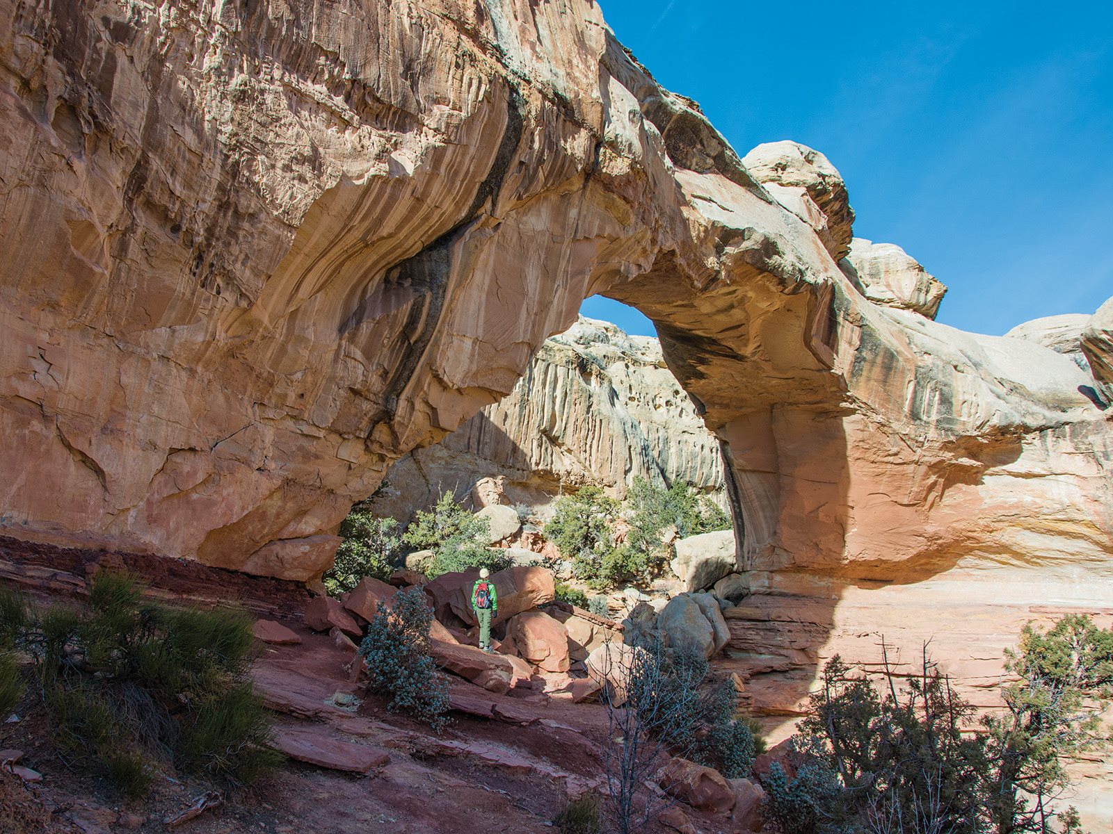
Torrey is the easiest place to sleep if your plan is Hickman Bridge, Fruita, Cassidy Arch, and the Scenic Drive. It keeps the trip simple without pushing you far from the entrance.

Peach trees in Fruita backed by red sandstone cliffs

Inside the park

Fruita Campground

Fruita details
Best for
Campers, orchard season, stargazing, and early trail starts
Tradeoff
Sites are limited, and services are simpler than town.
Planning detail

Fruita is the atmospheric choice: cottonwoods, orchards, cliffs, and quick access to the visitor center. Book or arrive according to current rules before you count on it.

Cathedral Valley monoliths rising from desert badlands

Remote add-on

Cathedral Valley and backcountry zones

Best for
High-clearance drivers, empty desert scenery, and self-supported nights
Tradeoff
Roads, weather, and water planning matter more than mileage.
Planning detail

Do this only when your vehicle, forecast, and recovery plan match the route. Cathedral Valley is a highlight, but it is not a casual dirt-road detour after rain.

Best base

Book Torrey unless camping in Fruita is part of the goal.

Storm rule

Skip narrow canyons and dirt-road loops when storms are possible.

Harvest timing

Fall lodging gets tighter when the orchards are producing.

Camping reservations

Camping reservations

Camping reservations for Capitol Reef

Campground systems change by season and sometimes by individual campground. Start with the official park camping page, then confirm open dates, reservation windows, and permit rules before booking.

Reviewed June 6, 2026

Booking window

Check the official park camping page before choosing dates.

  • Use the official park page as the source of truth for campground status, seasonal closures, and first-come rules.
  • Many federal campsite, backcountry, tour, and permit reservations are handled through Recreation.gov, but not every park uses the same system.

Where to book or verify

Official NPS camping page

Use this first for current campground status and park-specific rules.

Search Recreation.gov

Check for federal campground, backcountry, tour, and permit inventory tied to this park.

Permits and reservations

Use this for wilderness permits, timed systems, tours, and other park-specific reservations.

Getting there and practical info

Folded rock layers of Strike Valley in Capitol Reef

Plan the handoff from arrival to shuttle.

Parking, pedestrian entrances, and shuttle timing decide how calmly the first morning starts.

Getting there

Get to Capitol Reef, then remove the first-morning friction.

Nearest airport
Salt Lake City International (SLC), about 3.5 hours by car. Grand Junction Regional (GJT) in Colorado is a closer regional option at roughly 3 hours.
Access rhythm
Plan the last mile
Region
Utah
  1. Arrival note

    Capitol Reef sits along Utah Highway 24 in south-central Utah, roughly halfway between the towns of Torrey and Hanksville.

  2. Fly in

    The closest major airport is Salt Lake City International, about 3.5 hours north by car, while Grand Junction Regional in Colorado is a closer regional option at around 3 hours.

  3. Car strategy

    Many travelers reach the park as part of a loop through Bryce Canyon, which is about a 3-hour drive away on the scenic Highway 12.

Pair this with lodging: sleep where the park transfer is simple, especially if your route needs an early start.

LocationUtah

Frequently asked questions

Do you need a reservation to visit Capitol Reef?

No. Capitol Reef does not use a timed-entry or reservation system, so you can show up any day of the year. The main highway through the park is free, and only the Scenic Drive charges an entrance fee. You will want reservations only for the Fruita Campground during busy months.

Is there an entrance fee at Capitol Reef?

Entry to the park along Highway 24 is free. The fee applies only on the Scenic Drive, at $20 per vehicle, $15 per motorcycle, or $10 per person, valid for seven days. An America the Beautiful pass covers it.

Can you really pick fruit in the orchards?

Yes. The historic Fruita orchards, planted by early Mormon settlers, are open for picking when fruit ripens, roughly June through October depending on the crop. You can eat fruit for free while in the orchards and pay a small per-pound fee for anything you carry out. Check the current ripening schedule at the visitor center.

When is the best time to visit Capitol Reef?

Spring and fall are ideal, with comfortable highs in the 70s and 80s F and smaller crowds than other Utah parks. Fall also lines up with the orchard harvest. Summer is hot in the 90s F with flash-flood risk in the canyons, and winter is quiet and cold but offers striking snow-on-rock scenery.

Keep planning